|
MapGuide API Reference
|
|
MapGuide API Reference
|
Defines and manages the physical location of coordinate system data files. More...
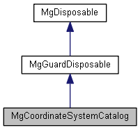
 Inheritance diagram for MgCoordinateSystemCatalog:
Public Member Functions | |
| virtual bool | AreDictionaryFilesWritable ()=0 |
| Checks whether any kind of definition supported by this catalog can be updated in the dictionary files currently in use. | |
| virtual MgCoordinateSystemCategoryDictionary * | GetCategoryDictionary ()=0 |
| Gets the coordinate system category dictionary. | |
| virtual MgCoordinateSystemDictionary * | GetCoordinateSystemDictionary ()=0 |
| Gets the coordinate system dictionary. | |
| virtual MgCoordinateSystemDatumDictionary * | GetDatumDictionary ()=0 |
| Gets the coordinate system datum dictionary. | |
| virtual STRING | GetDefaultDictionaryDir ()=0 |
| Gets the default dictionary path. | |
| virtual STRING | GetDefaultUserDictionaryDir ()=0 |
| Returns the default directory path where user defined coordinate system definitions can be found or can be written into, respectively. If set, this method returns the value of the MENTOR_USER_DICTIONARY_PATH environment variable. Returns 'CSIDL_LOCAL_APPDATA Geospatial Coordinate Systems' on Windows systems or an empty string on non-Windows systems, otherwise. | |
| virtual STRING | GetDictionaryDir ()=0 |
| Gets the current dictionary path. | |
| virtual MgCoordinateSystemDictionaryUtility * | GetDictionaryUtility ()=0 |
| Gets the coordinate system dictionary utility. | |
| virtual MgCoordinateSystemEllipsoidDictionary * | GetEllipsoidDictionary ()=0 |
| Gets the coordinate system ellipsoid dictionary. | |
| virtual MgCoordinateSystemFormatConverter * | GetFormatConverter ()=0 |
| Gets the coordinate system format converter. | |
| virtual MgCoordinateSystemGeodeticPathDictionary * | GetGeodeticPathDictionary ()=0 |
| Gets the coordinate system geodetic path dictionary. | |
| virtual MgDisposableCollection * | GetGeodeticTransformations (MgCoordinateSystemDatum *pSource, MgCoordinateSystemDatum *pTarget)=0 |
| Gets the geodetic transformations for the source and target coordinate system datums. | |
| virtual MgCoordinateSystemGeodeticTransformDefDictionary * | GetGeodeticTransformDefDictionary ()=0 |
| Gets the coordinate system geodetic transform definition dictionary. | |
| virtual MgCoordinateSystemMathComparator * | GetMathComparator ()=0 |
| Gets the coordinate system math comparator. | |
| virtual MgCoordinateSystemProjectionInformation * | GetProjectionInformation ()=0 |
| Gets the coordinate system projection information. | |
| virtual INT16 | GetProtectionMode ()=0 |
| Gets the protection mode of this catalog. | |
| virtual MgCoordinateSystemUnitInformation * | GetUnitInformation ()=0 |
| Gets the coordinate system unit information. | |
| virtual STRING | GetUserDictionaryDir ()=0 |
| Returns the current directory where user defined coordinate system definitions is obtained from or is written into. Returns an empty string if no such directory is currently configured for this catalog. | |
| virtual void | SetDefaultDictionaryDirAndFileNames ()=0 |
| Sets the default dictionary path and file names. | |
| virtual void | SetDictionaryDir (CREFSTRING sDirPath)=0 |
| Sets the path where the dictionary files are located. | |
| virtual void | SetProtectionMode (INT16 nMode)=0 |
| Sets the protection mode. | |
| virtual void | SetUserDictionaryDir (CREFSTRING sDirPath)=0 |
| Sets the actual directory where user defined coordinate system definitions can be found or can be written into. The directory set through this method must exist and writeable. If set to an empty string, the catalog's 'user defined coordinate system' directory will be unset and any updates will again happen only inside the directory as returned by GetDictionaryDir(). | |
Defines and manages the physical location of coordinate system data files.
 1.8.0
1.8.0