|
MapGuide API Reference
|
|
MapGuide API Reference
|
An MgCoordinateSystemGridRegion object consists of a label and a polygon. The polygon is always in the viewport coordinate system. Such an object is used, for example, to label and delineate an MGRS 100Km UTM grid zone. More...
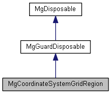
 Inheritance diagram for MgCoordinateSystemGridRegion:
Public Member Functions | |
| virtual MgLineStringCollection * | GetEastLine (void)=0 |
| Gets the east line of this region. | |
| virtual STRING | GetLabel ()=0 |
| Gets the label for this region. | |
| virtual MgLineStringCollection * | GetNorthLine (void)=0 |
| Gets the north line of this region. | |
| virtual MgPolygon * | GetRegionBoundary (void)=0 |
| Gets the boundary geometry of this region. | |
| virtual MgCoordinate * | GetRegionCenter (void)=0 |
| Gets the center of this region. | |
| virtual MgLineStringCollection * | GetSouthLine (void)=0 |
| Gets the south line of this region. | |
| virtual MgLineStringCollection * | GetWestLine (void)=0 |
| Gets the west line of this region. | |
An MgCoordinateSystemGridRegion object consists of a label and a polygon. The polygon is always in the viewport coordinate system. Such an object is used, for example, to label and delineate an MGRS 100Km UTM grid zone.
 1.8.0
1.8.0